I've written before about my early interest in roads - one that has never really gone away, and has often reawakened at times I've felt challenged or frustrated. That I now have a willing partner in crime who is happy to take sometimes quite lengthy excursions has meant that I've finally had the experience of driving on some of the roads I've mythologised over the decades. However, some roads are meant to be walked - roads which have existed in some form for hundreds if not thousands of years, which despite the layers of surface dressing, hide the oldest of byways beneath. Occasionally my explorations coincide with these roads and I find myself needing to walk out the obsession all over again. Today was a bonus - we were in London on route elsewhere, and I had an entirely free day in hand. While I'd immensely enjoyed the guided walk I'd taken last weekend, I wanted freedom to cover ground at my own pace. I was also disinclined to head back into the wilds for this - an excursion without mud felt like a good idea. I wanted feet tired from walking, not aching from slurping through the liquid surface of the Essex edgelands for a change. This all coalesced via a chance reading about the A503. I'd crossed Forest Road near Waterworks Corner back in February and had been mildly curious about its route. While useful and strategically important, this east-west cross route in the north of London is fairly insignificant in the scheme of things. In the west Seven Sisters Road is a product of the eighteenth century expansion of London and a former turnpike. To the east, Ferry Lane and Forest Road describe the route of the more ancient Clay Lane from Walthamstow to Epping Forest. Along this route, the humble A503 crosses the routes of many of my previous walks - the Regents Canal, Green Lanes, the festival of gentrification at Woodberry Down near the New River, the Lea Valley. It ends just shy of the North Circular - the ever present connection that writhes through this terrain. In short, the A503 was the perfect long slog for an unexpected walk - a chance to make new connections and revisit old ones.
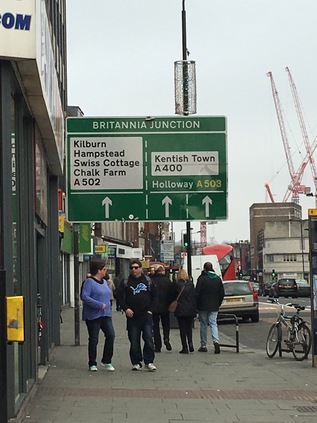
The bus deposited me on Camden High Street, a little north of Mornington Crescent. This isn't my favourite part of the world for a host of reasons, but mostly because in its slightly battered drag of chain outlets and copycat markets, Camden feels like what happens after gentrification. When I was a youngster, Camden was aspirational. The stars of British indie-pop propped up its bars, the record stores and vintage clothing outlets were legendary, the market was a wonder of new and old things which seemed exotic and impossible to us. It had developed this reputation slowly and surely through the 1970s, as the railway retreated and left large areas of land and old buildings free for exploitation. The real estate felt shaky and ill-kept, but that didn't matter to a post-squatter generation who liked their urban landscape to be edging into decrepitude. By the late 1990s, Camden was a different place. The huge footfall around the market and the High Street made the area attractive for the larger chains - and even though some of them were careful to invest their usually identikit outlets with a little uncharacteristic local personality, they were pricing out the smaller traders. Aside from the official market, every bit of clear land was taken up with semi-permanent stalls selling mobile phone cases, Bob Marley decorated stash tins, the usual stuff which could be found on the fringes of any shopping area. Each Saturday saw an influx of tourists eager to walk the High Street in order to pick up some of the perceived kudos of being seen around here, and the streets were full of expectant young faces from the provinces who - despite being in Camden - wanted the reassuring taste of McDonalds or KFC. First of all my route took a wide loop around this zone to find what might be the beginning of the A503 - heading counterintuitively west along Delancey Street and turning east again when I reached the bridge over the lines leading out of Euston Station. I'd strayed along this way in search of the bridge over a deleted arm of the canal, and knew the area a little. At Britannia Junction, the complex meeting of ways at the heart of Camden, I paused for coffee. I'd started earlier than usual today and needed the sustenance if I was going to make the distance. Looking out on what may or may not already be the road I was going to walk, I noted a gradual change. As the locals had headed for work or dissipated back into their homes, the steady stream of passers by appeared to gradually be shifting towards tourism. It was time to leave Camden.
I was briefly disorientated on crossing the street - Britannia Junction was a complex and many-armed beast. But the route I was taking almost immediately passed a familiar location - the same Sainsbury's I'd ended up detouring to find on my canal walk. I'd taken such a long circuit to get there last time that I'd lost the sense of just how close to the Canal I was for much of my Camden tribulations. This time I passed by, beginning to fit the area into shape in my mind - at least I'd have an escape route should I find myself here in future. As I slowly slipped out of the gravity of Camden the route began to change. Passing under the railway bridge at Camden Road station, beside its rusting and disused twin, I found myself climbing steadily on a broad suburban route. The stores thinned out into local hardware shops, convenience stores and petrol stations. The morning had started out grey but was clearing, and I was suddenly aware that the novelty of wearing a coat - something I've always studiously avoided until this winter when I finally found a comfortable and sensible garment for walking - was wearing off. I was far too warm. Getting an earlier than usual start on the walk and knowing I had accommodation in London overnight meant I could take a slightly slower pace than usual. No bad thing - this was quite a long route on pavement, with none of the diversion into the wilds I'd encountered recently on these walks. Despite having the time to divert and investigate things off route, I decided that wherever possible I'd stay true to the mission and indeed I largely stuck to the route I'd hastily planned. Above me the road was clearly marked: A503 Holloway, striking out north and east. Looking south when gaps in the row of tidy houses and small businesses permitted there were glimpses of the distant city as the road rose gently. Crossing the railway from St. Pancras on its broad westward curve towards Kentish Town, I sensed the change. I'd left the orbit of Camden, broken free and entered the uncertain northern hinterland which I'd spent so much time exploring in recent months. This part of North London doesn't quite cohere for me - districts blur and shift, and aside from the definite points marked by road junctions, the estate agents are drawing the maps here. The road stretched long and straight, reaching a peak from where I could see ahead to a fork. Where the road divided around a former garage with a gloriously modernist swooping roof, I took the left-hand path heading along Seven Sisters Road. Here, the A503 is a long one-way system enveloping Holloway completely in its two arms. Blank red-brick walls defined the perimeter of the former Holloway Prison. Empty and slowly returning to nature, the entrance was beginning to show signs of decay. It's just a matter of time before the sizeable site is snapped up and renamed to disguise its heritage. The area has a pedigree for residential land-grabs too - beyond the prison was a pleasant run of public housing owned by the City of London Corporation, one of the ten estates situated outside the square mile which it runs. Clean and tidy, the homes appear apparently well cared for and popular. I was prepared to find this part of the walk dull and mildly threatening but nothing could have been further from the truth. It is fair to say that Holloway is somewhere in the middle of a gentrification journey. Significant parts of the fringes of the area seem to be doing well, housing locals and providing decent services, while others seem to be undergoing that last, sorry stage of deliberate decay while their owners wait on the market and the right kind of investment into the area. At Nag's Head - where Seven Sisters Road meets Holloway Road - the scene is more disputed. As I lingered waiting for the confusing temporary lights on the crossing of the A1, I surveyed the area - it could be the centre of any London suburb, maybe even any small town perhaps. But among the well-known names and high street staples were a good number of tiny, local traders soldiering on behind long outmoded shopfronts. Beyond the stores to the north of the street was the muscular back elevation of the Beaux Arts Building on Manor Gardens. The front is a swirl of detail in brick, a grand Edwardian entrance to newly refurbished apartments - but the rear is stark, white and impressive. A single red brick chimney rises among the wings, which from above describe a trident pointing directly at the heart of London.
At Finsbury Park Station, the two arms of the road swing back together where the dome of the North London Central Mosque gleams over the three bridges carrying the railway north from Kings Cross. This mosque is something of a symbol of the triumph of peaceful Islam over extremism, with the Muslim Council of Great Britain seizing and reopening the site after a raid in 2003 which finally ousted the remains of the regime of Abu Hamza al-Masri. This splinter sect had been operating a programme of radicalisation from the building, some straggling tentacles of which reach forward into present-day terrorist activity. Emerging from the bridges, the transport interchange is a confusion of activity, with buses lurching around the tight curves outside the station. An unbroken stream of people are leaving the station with some Arsenal shirts already in evidence in advance of their FA Cup tie later in the afternoon. The sun had climbed above the buildings and I was starting to feel much too hot, but the road was curiously mesmerising - taking an almost straight course from district to district, through changing scenes which are both unfamiliar but entirely expected in their nature. North London is slowly starting to fit together in my mind, and the passing junctions connect me back to earlier excursons: the end of Stroud Green Road links me back to walking the Northern Heights. Everything finds its place here. Soon after passing the station the road quietened, and for a while it was just me and a constant stream of buses edging along the green fringe of the park. I'd walked this stretch before - between the treelined slopes and the long range of stucco-fronted hotels and large Victorian villas. It was pleasant to be out of the urban area for a while and to reorient myself by way of local landmarks: the towers of the Castle Climbing Centre and the forest of cranes at Woodberry Down. At Manor Park, I crossed Green Lanes and entered Hackney, completing my navigation of all arms of this important crossroads where the ancient road to the north crossed the relatively new turnpike. The organic cafe on the corner was busy - a signifier of how this area is changing, and indeed how quickly. The buses which have been shadowing me peel away north towards Wood Green and my route, now a broad dual-carriageway arterial, slips between the tall municipal blocks of Woodberry Down. On my left, some of the original blocks remain with their curved red-brick balconies - but as residents leave for the last time their doors and windows are securely plated over, the buildings slowly giving way to their regeneration. There's no rush to move them out - all the activity is to the south where the range of residential towers extends further eastward along the banks of the New River and the pair of broad, glassy reservoirs every time I visit. The desirable waterfront properties are for sale, not for rent, and definitely outprice the locals who are being slowly decanted from the ageing low-rise brick blocks. I popped into the local store and improvised lunch on the banks of the reservoir watching young couples leading curious children along the river path while ducks and gulls pecked around for crumbs. It was good to sit and cool off near the water and interesting to see how this area had changed since my earlier visits. The older population who had pottered the previous sandy incarnation of this pathway wasn't in evidence at all now, and there was a surprisingly homogenous feel. While the new buildings are undeniably a better environment in many ways, they don't appear to be fostering the sense of community which originally drove the aspirations of this early attempt at changing conditions for working people on a massive scale. Aware I still had some way to go, I set off to regain my route as it began a turn to the north at a crossing of the broad loop of the New River. Looking back along the inviting but still rather muddy river path, I had a view across the serrated rooftops of the somewhat directly named Harringey Warehouse District which sits at a distinctly lower elevation than the bank carrying the waterway. The A503 provides a boundary to Stamford Hill here, climbing respectably away from the factories and warehouses to the east with pleasant avenues leading away into Hackney. The walking was pleasant - perhaps a little cooler here, thankfully - and I relaxed into the rhythm of the traffic which was less intense along this stretch. The calm ended abruptly at the junction with St. Ann's Road which sat directly under the Gospel Oak to Barking railway line, the overbridge hemming the traffic into a complex junction and bottlenecking pedestrians into crossings which took an age to activate. Under the bridge it feels gloomy, damp and a little unsettling - perhaps reflecting the next part of the route? Looking ahead the road stretched onward between dilapidated and tired low rise housing and ranks of surprisingly attractive but mainly abandoned brick warehouses. Seven Sisters Road ghosts the missing edge of an incomplete diamond of railways here, the broad green areas of wasteland at its centre tantalisingly crossed by unofficial paths - but they're for a day when the ground is drier perhaps. A further railway bridge completes the diamond, and I'm in Tottenham - the change is imperceptible at first, but as I approach the A10 at Seven Sisters, the switch is suddenly closed. The tide of people waiting to cross the High Road couldn't be more multiculturally representative if an over-eager HR Officer had lined it up for a photograph. The junction throbs with life, a fog of traffic fumes undercut by the smell of barbecued meat and strong aftershave. Cars stopped at the light shudder with low-end from their speakers. Once, a ring of seven elm trees graced Pages Green - the original Seven Sisters - now a small linear park leads away east between the superstore and the terraced streets. The High Road is a stream of buses stretching north towards White Hart Lane and the tower blocks of Edmonton Green in the middle distance. For a little stretch I need to walk this route which absorbs the A503 briefly, marking a boundary between its distinct sections: the venerable turnpike and the ancient road across the Lea Valley.
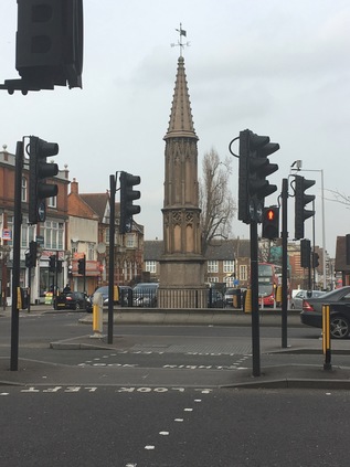
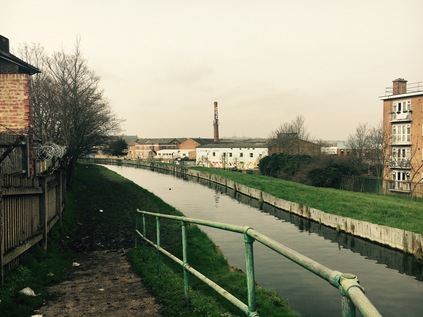
Tottenham High Cross is an ancient marker on the route of Roman Ermine Street, often confused for an Eleanor Cross but somewhat plainer despite some added ornamentation in the early 19th century. Here I turn aside and head down into the valley, taking the appropriately named Monument Way. After a brief detour into a retail park at Tottenham Hale which feels oddly makeshift and provisional, I cross the vertical obstacles which separate North and East London - the Eastern Counties Railway, Pymmes Brook, Lea Navigation and the River Lea pass under the road in rapid succession. The valley bottoms out into a broad plain which has been flooded to form the chain of vast reservoirs which shadow the river here. After the Ferry Boat Inn, marooned on a spit of land between the Lea and the Coppermill Stream, the road joins a narrow causeway between these manmade lakes, with the railway curving in alongside. The gates of High Maynard Reservoir are locked to all except licensed fishermen - a regiment of heavy padlocks securing the gates, while wading birds strut the banks like guardsmen. Along the causeway unfinished electrification gantries from the recent railway works become a row of ominous monuments. In the distance I can see the land rising away from the valley floor, and I realise just how far I've got to go to reach my self-imposed destination. I'm distracted by designs etched into the pavement showing the transition: from industry and water to entertainment and nightlife. The progress from borough to borough is marked carefully - Waltham Forest wants us to forget the lines of pylons marching behind us and the broad swathe of churning green water. Ahead is art, culture, food and wellbeing. This once downtrodden borough is getting a very public makeover, its various urban centres being remodelled to promote promenading and restrict the motor car. Walthamstow is changing. I've seen the 'Awesomestow' banners - that clumsy appropriation fails on so many disturbing levels. I've also seen the row of achingly retro stores on the corner of Blackhorse Lane - the 'home of people who make and create' and I've seen the rebranding attempts as I've skirted the district, but today I'll be facing it squarely as I make a transit across Waltham Forest towards the east. I don't object to this area - in fact I rather like it - but I don't need to have this unsubtle exercise explained to me. Let us all discover - or rediscover - the borough. Don't force it, Walthamstow.
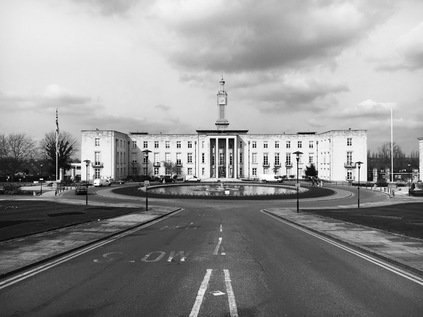
This is now Forest Road, and as it makes eastern progress away from the Lea Valley the stores return to type: small newsagents sponsored by Lebara and occasional hair salons. The pedestrian schemes are still incomplete out here, and the traffic remains dominant. Long ranks of tidy suburban avenues lead north and south and the road is fairly unremarkable aside from a fine modern Fire Station building. Rather suddenly, the carriageway kinks to the south to skirt the grounds of Lloyd Park House - now the William Morris Gallery. This sizeable but modest building sits at the corner of a broad green space beyond a walled garden, which is apparently well-used on decent afternoons like this. Formerly Water House this was the Morris family home from 1848 to 1856, while the adjoining Lloyd Park includes a moat which long predates the Georgian building. The space in front of the gallery offers a moment to rest and reconsider the walk - not least how I'll escape from the end of the road when I reach Waterworks Corner. I hadn't really planned for this - the road had seemed impossibly long, and the chance to walk without worrying too much about time had lulled me into not considering how I'd mark the completion of the walk. There was a way to go yet though, and as the road climbed towards The Bell and a house-sized mural of Morris glared across at me, I had a view of the distant green horizon where I was heading. My route skirted north of the central area of Walthamstow which clusters around busy Hoe Street, and remained resolutely suburban until I crested the rise and looked down on the pale verdigris of the clock tower topping Walthamstow Town Hall. As I approached, the full extent of this impressive civic complex unveiled itself: first a broad, low magistrates court building now closed and sold to the Borough Council as part of the Ministry of Justice estates rationalisation. This patently 1970s creation of the GLC Special Works Department can't truly be considered a brutalist structure, as it relies on Portland Stone to offer its simple but muscular face to the world. Beside it sits the more classical but no less imposing Town Hall by Philip Dalton Hepworth - a broad, mausoleum-like sweep of stone completed against all the odds in 1941. Its geometry aligned with a central fountain and a processional route to the doors, and I found myself precariously perched between the gates while trying to snap a picture. A citizenship ceremony was being completed as I approached, with impeccably dressed celebrants leaving the campus to the disgust of a couple of locals who leaned on railings, spitting and moaning about them "not being really British". As they'd inadvertently roped me into their conversation I pointed out that that was now exactly what they were. More spitting, more moaning about this 'fuckin' lefty'. Finally, the broad colonnade of the Assembly Hall completed the site and Forest Road began to climb again, passing the extensive Waltham Forest College buildings. This area is rigorously zoned, these public buildings dominating the east-west road as it cuts across the ridge between the Lea and the Roding. Nearby, a grandmother passed me, stooping to encourage a young girl and reassuring her in a surprisingly breaking voice that they'll do something "when mummy gets out". Initially I'm confused by the significance - but I soon spot Thorpe Coombe Hospital, a Georgian house turned into a Health Trust building with a residential psychiatric unit on site. I find myself sharing the young girl's pain and confusion, the sense of separation and the power of places to divide and distance. I'm surprised how this part of Walthamstow has passed me by before - the odd gravity of this administrative complex which powers the district like a civic engine room, dealing with its difficulties and tidying away the awkward and ill-fitting. I felt strangely ill at ease as the road turned uphill again, the horizon lost behind the ridge and the rising streets of Walthamstow behind me, if I'd dared to look back.
As I climbed, somewhat unexpectedly the deck of a footbridge appeared above the road - and as I slogged further up the rising path, the steep grassy banks supporting it emerged and I realised with some surprise that I was almost at my goal. The flat grassy deck above the sunken reservoirs opened out, and I could see the spot where I scrambled thankfully down from the forest path on my last walk here. Ahead of me the A503 ended at an unusual urban cattle grid near a junction with Woodford New Road, just shy of Waterworks Corner roundabout. I had mixed feelings as I approached the end of my walk - firstly, that I should perhaps press on further east, following the North Circular? The transition I'd made from the fading glamour of distant Camden to the leafy suburban spaces of Woodford felt jarringly odd and unresolved. As I circuited the roundabout to find a path across to the northern side of the shuddering and screaming A406, I noted the forest paths were still awash with thick mud and deep ruts. The subways under the roundabout were little more than continuations of the forest trail with strict instructions for horseriders to dismount. Beneath me, huge eastern European juggernauts paused in the lay-bys, the soles of their drivers' feet propped at the windows as they sleep until they're permitted to drive on. The traffic noise reverberated through the tunnels as I negotiated a route out onto Grove Road which edged along the deep concrete gouge which channels the road. The sun was beating down now, and there was a remarkably long view into the eastern distance. As the land fell away into the Roding Valley I had a clear vista of rooftops and distant woodland, and rather shockingly protruding from within the woods I saw the tower of Claybury Hospital winking into the spring sunshine. For a while I sat in the strange little makeshift seating area on the edge of Woodford where the North Circular cannons underneath the urban centre. A steady procession of happy young faces trotted into town, buses shuttled back and forth. It felt strangely peaceful - like the road echoing below my seat wasn't really there. I shuffled creakily into South Woodford to find a bus stop, conisdering that it could be any town centre in the home counties. Over my shoulder the tower signalled from my previous walks, shimmering over the ranks of heavily mortgaged Essex real estate. I was back in comfortable territory on the edge of things, but not everyone here was comfortable or secure. I thought of the girl and her grandma shuffling west from the civic centre of Walthamstow and of the sorrowful history of Claybury and its sister asylums, and I felt very grateful I was heading back to my own tiny family.
A gallery of pictures from the walk can be found here.
Lost::MikeGTN
I've had a home on the web for more years than I care to remember, and a few kind souls persuade me it's worth persisting with keeping it updated. This current incarnation of the site is centred around the blog posts which began back in 1999 as 'the daylog' and continued through my travels and tribulations during the following years.
I don't get out and about nearly as much these days, but I do try to record significant events and trips for posterity. You may also have arrived here by following the trail to my former music blog Songs Heard On Fast Trains. That content is preserved here too.