The Calm Before The Storm - A Last Pre-Olympic Walk
Posted in London on Saturday 26th May 2012 at 10:05pm
Just now, the whole world seems to be on pause. Events are grinding to a halt to accommodate the twin national patriotic rallying points of the Diamond Jubilee, and more disruptively the 2012 Olympiad. I've written copiously about this, fact and fiction, and I risk painting myself as an obsessive if I'm not careful. Already, it's assumed by many that I'm nothing more than a disciple of Iain Sinclair who can't form my own opinions on the issues as I'm not resident in those distressed eastern environs. Well, much as I admire Sinclair's stance and very much love the way he expresses it, my own view has been formed by passing through the site over the six years since work began, watching it change in character and tone - and most alarmingly in it's loss of the sense of being a public wilderness. But I've never quite dared to walk the waterways myself - afraid of bumping into others like me who are compelled to visit despite doubting the wisdom. I realised though that time was running out. And so, I had to act.
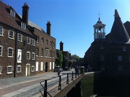
The stars aligned when the London Topographical Society published a walk around the park. By the time their twice-annual journal landed the walk was dangerously out of date, but with a day in London and only the loosest plans I decided to tackle it in preference to other less pressing treks. It was, by far, the hottest day of the year - and perhaps for many years - as I stepped out of the train at Paddington. I breakfasted at leisure and took the 205 bus to Bow Road, a long and sluggish, but as ever interesting transit from suburb to suburb avoiding the city's core. Here I decided to use the Underground for the last leg to Bromley-by-Bow, just to avoid too much diversion before the walk began in earnest - and because there was a sense of purity beginning the walk by popping out of the ground rather than seeing the landmarks of the Olympic Park arise gradually. I surfaced again beside the Blackwall Tunnel Approach Road. Passing under, and calling briefly into Tesco for water, I found myself giving to the local foodbank too. It felt right to pay tribute to those struggling in this hostile environment before setting off into Three Mills Lane. This triangle of reclaimed land between Bow Creek and the Prescott Channel is now far from the run-down, dereliction it once was - as it's home to a large complex of film and TV studios occupying two of the former mills, with a great deal done to preserve the character of the area. Crossing the Creek, I noted a tour group huddled around "Tony", their guide. He'd been outside Tesco earlier, holding up a sign saying "2012 Official Tour" and had looked quizically at me, obviously guessing I was a tourist of sorts. Now he was explaining the significance of the area's waterways, linking it back to the Olympics. The group, mostly non-British were a mix of experience-seeking adults and their teenage offspring who looked by turns bored and confused. I pressed on to Three Mills Green. Immaculately manicured, and a rather pleasant spot to absorb the sunshine, as a few locals lolled around on the grass never slow to take the opportunity for a free tan. I walked to the eastern edge of the green to gain a view of Abbey Mills Pumping Station across the tangle of allotments, and the new lock installed to allow building materials reach the Olympics by water. It was in the process of building this that lumps of the Doric Arch from pre-electrification Euston were dredged up, and now sit in storage somewhere awaiting the next development opportunity there. Edging around the park I noticed the tour group again, perched on the rather impressive polished concrete ping pong tables. Lingering in the sun to let them pass, I encountered them again near the Three Mills Wall River as Tony rattled off significant dates in Olympic History. He broke off briefly to ask if I was "trying to get a free tour or something?". I showed him what I was doing, and told him my own history as a guide of walks, and he seemed more relaxed and chatty. He talked about how business was good, how he could do seven or eight of these trips each day if pushed, and how he'd considered charging £20.12 for the walk - but "couldn't carry all that facking change about". He said I wouldn't be able to follow the planned route and "I'd see why" before returning to his group and saying "I can't get you into the Olympic Park - no-one can - but I can tell you about what we can see, and what you can't". On this metaphysical point, I left him to it. Veering onto the tight towpath I headed onwards passing a 'phone mast disguised as a giant Olympic torch as I emerged on the busy strip of Stratford High Street. Passing cars kicked up clouds of building dust, and my nostrils complained bitterly at the assault. I was sick, but determined not to let a summer cold stop this final walk before the games began.
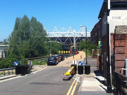
The tangle of navigable waterways here was once a necessity due to the congestion and the politics of using the various routes. A price war between canal owners led to these channels becoming part of the vast canal network, and because of this they remain in the ownership of British Waterways. Here, my aim was to use the towpath of another stretch of waterway, the Bow Back River, to reach the Greenway. I crossed the High Street at the lights. Nearby a new bridge, apparently temporary, had been constructed to carry this footway over the road to cope with large Olympic crowds. How many would realise that their walking route was in fact a large, Victorian sewer I wondered? Turning west, I passed City Mill Lock and the river of the same name coming in from the northeast, before surfacing on Marshgate Lane. Here I was due to head up Pudding Mill Lane, beside the now beleaguered DLR station, and to ascend onto the Greenway. However, this was out of the question - Tony had been right. As I poked around trying to figure out the best way to go, a security car drew alongside me and three bored but edgy looking men clambered out. "Path's closed unless you want the DLR" he offered. I replied I was after the Greenway. "Why?" he asked "Been closed for months now. You can't get up there until after the games". The Greenway has been used a means of viewing the park since the build began, even playing host to a dedicated viewing position called View Tube and an associated cafe. Now, in the distance I could see it - a high-fenced channel running through the site like a bristling, protective spine, parts of it due to provide public access to the games while others apparently served as a sort of linear sentry emplacement for the security services. As I wandered off he called after me "No pictures, we know you've been taking pictures and you can't. Not here. It's illegal". I didn't turn back to argue the point. I got the sense that in training these people to protect this national spectacle, they've been told to expect something to happen. Every interaction, every encounter could be that event - and they are hyper-sensitised to it's potentiality. In short, these men felt dangerous to be around.
The official diversion signs took me back to the main road, and almost to the throat of the treacherous Bow Interchange which continues to claim the lives of hapless cyclists despite being part of Boris' Cycle Superhighway. Just before I arrived at the dusty concrete wilderness, a bridge and a stair dropped down to the path beside the River Lee Navigation. I gladly followed it into the cool green tunnel. Walking north, the high fence of the park with its razor wire and frequent CCTV points soon came alongside. Accesses from the towpath were discretely but absolutely closed, booms and anchor points ready to close the river to boats and this main towpath to feet and cycles as soon as the event begins. I felt unwanted - and I felt like I was being watched once again, shrugging off the suspicion as irrational but never quite escaping the sensation. However, there were lots of us walking - and there was an unspoken code of nodding or just exchanging morning greetings. Cyclists mostly rang their bells to warn of their passage too. A gently defiant population using the route, adapting to diversions, refusing to be excluded from their wilderness - and as I began to enjoy the walk despite the dust and heat, my wilderness too. We were trapped in a channel, an oddly idyllic single approved pathway through the chaos of the unfinished park above. As adjoining streams came in, I noted their walkways blocked by the last vestiges of the blue wooden fence that once demarcated the whole site before the security fence came. Little bits of ODA history, a history of corruption and displacement, preserved down here where no-one will look.
Continuing north, I came to a spot where two huge pipes leapt over the river, and a substantial bridge crossed. It was clearly marked "Northern Outfall Sewer" and a sense of frustration briefly surfaced that I should be above this spot. The path zig-zagging up to the Greenway was closed, mesh gates and razor wire installed - a huge hospitality zone was being formed above from solid plastic mock-pagodas. But I realised if I had made that direct, diagonal swipe across the park I would have missed this walk through a geography I'd only seen from the railway above. I'd passed on foot the same cement works and sidings which were a tantalising glimpse of what might have been covered on railtours past. Continuing, the river opened out into a junction, with the other route closed by more blue signs. This river, from consulting the map, is the one which carves into the park behind the stadium, creating the Olympic Island and dividing the public areas from the Athlete's Village and other prosaic service sectors. Unsurprisingly, it's now entirely impassible, and I found myself instead crossing a narrow bridge to reach Old Ford Lock. Sitting on the edge of the lock apparatus for a much needed drink, I spotted a familiar sight through a fence. Now a private house, but unmistakable, was the former home of the Big Breakfast TV show. Beyond it, towering above a line of trees was the Olympic Stadium, looking more sinister than ever in this context. I turned and headed west. There was another security guard at the lock, less sure of himself on this non-Olympic property he just whispered into his radio and watched the procession of walkers and cyclists enjoying the weather.
The next part of the walk took me onto Fish Island and into the depths of Hackney Wick. I'd skirted this area previously on an ill-fated dash to escape from Milton Keynes, inexplicably drawn to it but also rather afraid of getting sucked into another desperate corner of London. As I plunged between former warehouses now become artist studios for the likes of Bridget Riley, I turned a corner and happened on a strange scene. On Dace Street, a glamourous but trouble-lined woman in an elegant evening dress was running a junk stall on the pavement, bohemian students picked over her wares and bargained over seventies crockery and oddly shaped lamps. Across the street in a reclaimed warehouse space a makeshift barbecue was cooking, with wonderful smells emerging. Another dilapidated warehouse block housed a cafe, offering ethically sourced goods and claiming to be London's finest. People milled around lazily. Despite being largely ignored I felt out of place in the urban oasis and swiftly passed by to reach the Hertford Union Canal via another footbridge. An ill-starred and little used stretch of water which never quite made the fortune it cost to dig, this cuts dead straight though Hackney Wick towards Victoria Park which was my final target. Having passed under the Blackwall Tunnel Approach Road once again, a little before the ramp up to Cadogan Terrace, I noticed a strange bridge abutment practically in the back garden of a house it seemed. On checking later, I realised that this was the route of the railway to Poplar, once a passenger route and then a busy freight line. It was lifted in the 1980s, isolated and unused beside the Eastern Cross Route, its stations long closed. Only a few years later, the DLR took over it's southern reaches, but then turned east via a new route to get to Pudding Mill Lane and Stratford. The imprint of the junction at the former Victoria Park station is still visible, with trains now shuttling between Richmond and Stratford, straddling the Westfield shopping empire completely. Suddenly all of my interests and curiosities were coming together strangely in this tiny patch of dwindling wilderness amongst the city.
I lingered for an hour in the park, watching the sunbathers, frisbee players and walkers pass by. Looking back, the stadium leered angrily over the houses and trees, seeming very close indeed. Just two years ago, it hadn't been nearly this omnipresent or oppressive, barely showing over the curtain of trees. I made my way to the bus stop, elated from completing my walk but troubled by some of what I'd encountered. Oddly, my instinct was to return to the rails and take the diverted train service which curved through the geography I'd just walked from above. As we crawled into Stratford station, and the curved platforms which take the line to Coppermill Junction, I looked down on the tow path and the cement works, and peered hard into the tangle of green which marked the line of the river. The trickle of walkers and cyclists continued, the sun beat down on the dusty path and there was a heat haze rising over the stadium. In the still chaotic spaces around the main venues, security Land Rovers ferried back and forth, men muttered into radios and eyed with suspicion people passing on their way to shop at Westfield. I probably had left this walk a little too late, but I couldn't imagine a better day to have done it.
You can see more pictures from the walk here. As an experiment, you can also follow the route on the map below - the blue line is the walking route, the red line the rail journey.
View Pre-Olympic Walk in a larger map
Lost::MikeGTN
I've had a home on the web for more years than I care to remember, and a few kind souls persuade me it's worth persisting with keeping it updated. This current incarnation of the site is centred around the blog posts which began back in 1999 as 'the daylog' and continued through my travels and tribulations during the following years.
I don't get out and about nearly as much these days, but I do try to record significant events and trips for posterity. You may also have arrived here by following the trail to my former music blog Songs Heard On Fast Trains. That content is preserved here too.